|

Bucks Geology Group
Whiteleaf Nature Reserve
Grid reference: SU 8215 0370.
Ordnance Survey map:
Aylesbury and Leighton Buzzard Sheet 165.
Geological maps:
1:50,000 series Thame sheet 237 and Aylesbury sheet 238.
Bucks County Council administration area:
Wycombe District (site code:80H11).
Owned by:
Bucks County Council; Managed by The Chiltern Society. Contact them directly
at White Hill Centre, White Hill, Chesham, Bucks, HP5 1AG Tel: 01494 771250
Area of site:
27 acres.
Access, location and parking:
From the A4010 at Monks Risborough take the road signed 'Whiteleaf'. Park in the Whiteleaf Hill Car Park, next to the Ridgeway access point. This is a large car park, suitable for groups using cars (coach access prohibited by low bar at entrance). There is also information on Whiteleaf under 'Education' with work sheets for schools.
Whiteleaf can be separated into two parts:
1.The nature reserve (requiring no permissions)
2.The old quarry (requiring a key and permission to enter)
1. The Whiteleaf Nature Reserve
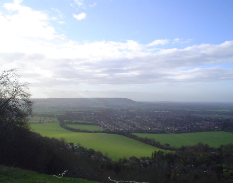
The geological interest lies in the demonstration of how geology controls landscape - in this case the typical Chilterns landscape of dip and scarp slopes, and vale. From the viewpoint there is a good view of the scarp slope and the Vale of Aylesbury. A geological interpretation of the spectacular view is present at the summit. Visits can include a geological trail around the site to develop the 'hunt-the-rock' theme - looking for clues of the Chilterns geological history (e.g. evidence for Chalk is to be found in the famous Chalk Cross cut into the flanks of the hill, Chalk and flints are seen in the worn parts of pathways and in uprooted trees, and clay-with-flints covers the top of the hill).
The site lies within Green Belt and within the Chilterns area of Outstanding Natural Beauty. It makes a prominent feature on this part of the Chiltern's escarpment above the town of Princes Risborough . The geology is primarily one of Chalk (Cretaceous in age) overlain by Clay-with-flints (Tertiary). There are exposures in the Middle and Upper Chalk (from Chalk Rock and the Lewes Nodular Formation), with occasional finds of fossiliferous flints.
The site also displays a number of geomorphological features. From the viewpoint, the control of geology on landscape can be seen and within a very short distance from the site the outcrop areas of Lower Cretaceous and Jurassic strata can be reached. In general the area is divided into the clay lowland of the Aylesbury Vale and the Chalk escarpment. The latter is dissected by numerous dry valleys. The clay vale is dissected by the modern river courses, and it is interrupted by a mid-vale ridge of harder, topographically higher outliers.

The majority of Monks Risborough and Princes Risborough lies on the pale grey, chalky clays of the Lower Chalk. The ground surface begins to rise gently across the Lower Chalk outcrop from just over 100 m to c. 120 m in height The Melbourne Rock is a hard bed which forms another notable ledge on the topography at the foot of the escarpment and marks the boundary of Lower and Middle Chalk and lies in the fields beneath - just before the housing areas of the town. There is a second line of springs at this junction - marking the more porous Melbourne Rock with the clay-rich and more impermeable Lower Chalk. The Upper Icknield Way path crosses over the Melbourne Rock which can sometimes be recognised in the worn footpath at SP 818 040.
The steepest incline of the Chalk escarpment, which rapidly increases to c. 200 m, is formed by the Middle Chalk. The uppermost 10 m of the Middle Chalk is visible in the bare parts of the slopes at Whiteleaf below the Whiteleaf Cross (SP 822 040, see figure below). This uppermost section can be seen to contain some flints (but not as numerous as the Upper Chalk).

The Chalk Rock has been a common building stone in the past (often called 'Clunch' by the Victorians) and is a harder bed marking the boundary between the Middle and Upper Chalk (the base of the Lewes Nodular Formation). This can be seen in the small quarry exposure close to the road. The Chalk Rock is a hardground which often contains numerous Thalassinoides burrows and represents several periods of breaks in sedimentation of the normal Chalk.
Both the Middle and Upper Chalk are well-cemented, pure white limestones. The difference lies in the thin and occasional marl bands in the Middle Chalk and the distinctive bands of flint within the well-bedded Upper Chalk. The Middle Chalk can be best seen in the small quarry reached from a pathway running from the Whiteleaf car park (adjacent to the road). The Upper Chalk makes up the remaining 50 m of the topmost escarpment slope along parts of this hillside.
The deposit lying directly on the topmost Chalk is Clay-with-flints. This is a residual deposit formed from deep weathering of the Chalk. The Clay-with-flints has a patchy distribution which follows the topmost escarpment and dip-slope, but it is dissected and removed along numerous dry valleys. Clay-with-flints is usually a reddish-brown clay containing lots of angular flints (up to 50% flints). Sometimes it is a yellow clay or a reddish-brown clayey sand. Whatever its overall appearance it is a Chalk solution residue which is often added to by illuvial clay from the overlying Tertiary or Quaternary deposits.
The dry valley systems were cut during the Ice Age. Although these valleys are dry today, they were once the site of torrential flow from melt waters of a retreating ice sheet and melting snow. They are common features throughout the Chalk escarpments of southern England , not just the Chilterns. The majority show the typical form of a water-cut valley - fairly steep sides, an asymmetry in form and an overall v-shaped profile. Today water does not flow over the Chalk outcrop as chalk is normally a highly porous rock. Numerous fractures and pore spaces ensure water permeates through the rock very efficiently to the water table. However, under tundra conditions the water in pores and fractures becomes frozen and water is forced to flow over the surface. In this way, deep river channels can be cut down relatively rapidly. As soon as the climate ameliorated, permanent frozen ground thawed, and the normal drainage system and porous nature of the Chalk was resumed.
There are also deposits within dry valleys, for instance, the Princes Risborough Sand and Gravel, which were deposited by a southeasterly flowing river - an ancestral River Wye (after the dry valleys were cut). This river ceased to flow when the tributaries leading to the ancestral Thame developed and created a different drainage system. The deposit is rich in chalk and flint pebbles and lies in a very restricted area on the escarpment known as the Princes Risborough Gap. This deposit (and others like it at the bottom of dry valleys) comprises sands and gravels that are rich in chalk and flint. At the surface this deposit is always decalcified to form a reddish-brown, sandy loam with abundant flint pebbles (angular and rounded).
The ecological interest lies with areas of 'typical' Chilterns beech woodland and flower-rich chalk grassland. Contains ancient woodland with beech, oak, ash, sycamore, whitebeam, yew and holly.
The archaeological interest lies in the ancient barrows (tumuli) on the summit (although there are also 'lumps and bumps' in the woods which are not geological and must have an archaeological interpretation). The archaeological and historical interests are:
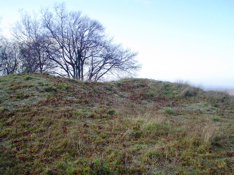
1. a Neolithic Long Barrow (Scheduled Ancient Monument No. 19053; Archaeological Notification Site Ref. 1649), Figured below;
2. Bronze Age Round Barrow (bowl type) (Scheduled Ancient Monument No. 19048; Archaeological Notification Site Ref. 1649);
3. Bronze Age Round Barrow (bowl type) (Scheduled Moniument No. 19047, Archaeological Notification Site Ref. 2141);
4. Cross Ridge Dyke (Archaeological Notification Site Ref. 1649);
5. Whiteleaf Chalk Cross (Scheduled Ancient Monument No 5. Archaeological notification Site Ref. 1649.
6. First World War practise Trenches (Notification Site Ref. 5605).
The Ridgeway National footpath also crosses the site.

Neolithic burial mound on the edge of the escarpment
2.The old Chalk Quarry (requiring a key and permission to enter):
This quarry was worked for some of the harder chalk layers which have been used in the lower layers of the road.
What is Chalk? Chalk is a very pure limestone which is almost entirely made from the mineral calcite (calcium carbonate). This mineral is readily attacked from acid solutions (and even natural rainwater is slightly acid), so limestones such as the Chalk are very vulnerable to chemical weathering. This is partly the reason for Chalk hills, such as the Chilterns, weathering to such a soft rounded form.
Chalk is made from the tiny skeletons of marine algae called Coccoliths. These are so tiny that many thousands of them would fit on a pin-head! In fact, they are so small that they remain buoyant in the water even after death - they would not normally settle to form sediment on the sea floor. So why are they here in the Chalk in this quarry? Each one has been eaten by an animal (animals such as shrimps love algae). Once digested the tiny plates of the algae are deposited, as excrement, on the sea floor. So it would not be incorrect to think of Chalk as shrimp poo!
A coccolithopore:

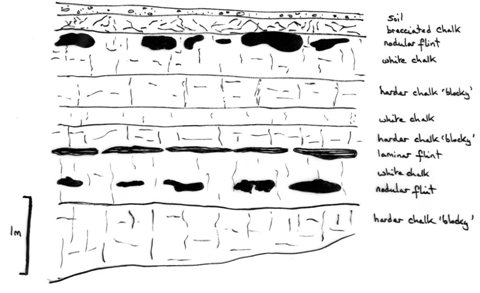
The Chalk in this quarry section is fairly hard. It is the topmost part of the 'Middle Chalk' (the Lewes Nodular Formation, with the Chalk Rock Member at the base). Although the beds become weathered and start to crumble you should be able to pick out various layers if you look carefully. These beds are typical of this part of the chalk formation - they are reasonably hard with softer, more clayey layers, and with flint - sometimes in nodular layers and sometimes in flat layers (laminated).
The slightly hard, more blocky, layers alternate with slightly whiter and softer chalk beds. This is reflecting the regular changes in the conditions that produced the Chalk millions of years ago. The harder beds have acquired a better cement.
What is flint? Flint is made from quartz. This is an extremely hard and robust mineral and ensures that flint is a tough rock that does not weather easily. It takes many millions of years to form the decayed white rind (called the cortex) that you see around the shiny black flint nodules. Flint forms just beneath the sediment surface where quartz in solution in sea water is mobilised by a 'trigger'. This trigger is commonly a lack of oxygen. Here, in this quarry face, you see two types of flint: nodules and laminar. The nodules will have undoubtedly formed around a dead and decaying animal - sponges are very common fossils found in the centre of flints. Some flint is long and cylindrical - an indication that it formed within burrow systems (mostly burrows of shrimps by the look of the size and shape).
The laminar flint tells a very dramatic tale - an indication that the ocean currents became disrupted and oxygen was cut off to this part of the sea-floor, thus promoting a flint layer over the whole surface. This event can be seen over the whole Chilterns, the South and North Downs and indeed over lots of Europe! It is due to the sea level becoming so high that the path of ocean currents became disrupted. These currents are needed to replenish oxygen, without ocean currents the seafloor soon becomes anoxic and animals die.
Below: The quarry face & sketch of the layers seen when cleaned with a trowel


|


