|
Bucks Geology GroupLower Greensand Formation
The earliest Cretaceous Period in Britain saw a great diversity in geological environments. To the Northeast, marine conditions prevailed, at the western edge of a muddy Boreal (northern) ocean which stretched far across the Russian Platform. To the south, a vast area of freshwater marsh, lake and stream sedimentation had formed, between the semi-permanent London Platform and island areas in France and Southern Ireland. From the end of the Jurassic Period, for about 40 million years, Buckinghamshire was predominantly exposed land, and little, if anything remains of any continental sediments deposited at this time (the one exception being a small deposit of sand, once exploited at Stone, west of Aylesbury, which was thought to be a contemporary river channel deposit). Indeed, the principal process was erosion, most noticeable nearer the London Platform, from which much of the more recent, soft Jurassic clay deposits were removed. From the early Cretaceous, sea-level started rising (culminating in the record highs during Chalk deposition). From about 115 million years ago, during the late Aptian to Early Albian Stages, a seaway finally broke through, uniting the northern and southern seas at last. Areas of lower elevation were able to infill with material being eroded from the surrounding higher land, effectively levelling off the topography.One such low area existed in eastern Buckinghamshire, Bedfordshire and farther east. This basin filled with sand, silt, a little clay and some ironstone. This sand formation, known as the Woburn Sands, now forms the Brickhill ridge, which extends into Buckinghamshire, south of Milton Keynes. Most of the sands in neighbouring Bedfordshire, adjacent to the Buckinghamshire boundary, were deposited near land, in a tidal estuary, as sand bars at the estuary mouth, and finally tidal flats with rare floodwater channels. Tidal bedding, large fossil logs, and some brackish to freshwater algae microfossils help the interpretation. The Fullers Earth clay, which is quarried near Brickhill, is particularly interesting as it is nearly pure bentonite, a volcanic clay. The location of the volcano remains a mystery, although to the west of Britain is the most likely candidate.
The Lower Greensand Formation Stratigraphy
Photographs of the Lower Greensand FormationHover cursor over photograph for label.
Rocks and Fossils from the Lower Greensand Formation
Further reading suggestions:
Horton, A. 1995. Geology of the country around Thame. BGS memoir to geological map sheet 237. Sumbler, M.G. 1996. British Regional Geology - London and the Thames Valley. BGS. HMSO.
|


 Lower Greensand [Woburn Sand Fm.] Reworked Jurassic ammonites preserved in Early Cretaceous age sediments of the Woburn Sand Formation, Potton, Bedfordshire.
 Lower Greensand [Woburn Sand Fm.]. Ferruginous sandstone with fossil wood, Silver Sands unit, Woburn Sands, Mundays Hill, Bedfordshire.
 Shenley Limestone. Brachiopod: Terebratula sp. Mundays Hill, Bedfordshire.
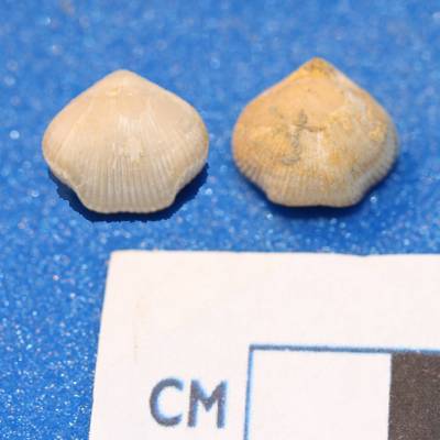 Shenley Limestone. Brachiopod: Burrirhynchia leightonesis. Mundays Hill, Bedfordshire.
 Lower Greensand [Woburn Sand Fm.]. Tidal silts and Muds with bioturbation, Silty Beds - upper unit of Woburn Sand Fm., Mundays Hill, Bedfordshire.
 Lower Greensand.Fossil Wood in iron cemented sandstone, Mundays Hill Quarry.