|
Bucks Geology Group
Ivinghoe Beacon
Grid reference: SP 940 150 to 970 180.
Ordnance Survey map:
Aylesbury and Leighton Buzzard Sheet 165.
Geological maps:
1:50,000 series Aylesbury sheet 238.
Bucks County Council administration area:
Aylesbury Vale.
Owned by:
National Trust.
Area of site: ha.
Access, location and parking: Site access is via the B488 and parking in the National Trust car park which is well signed as Beacon Hill. There are no amenities on site, the nearest facilities are to be found in the village of Ivinghoe where there is a pub and a cafe.
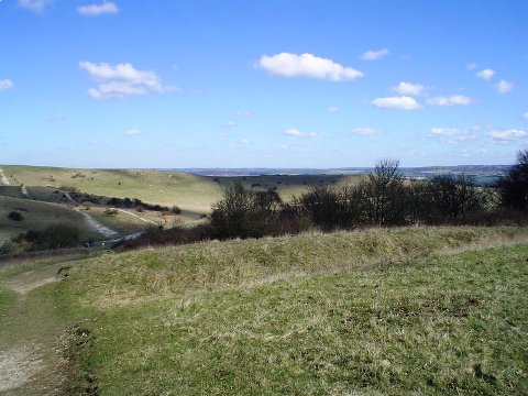
Interest Summary: This is a beautiful location on Chalk
hills offering spectacular views of the vale and of dry valleys. A high point of the Chilterns affording good views of large-scale control of topography and scenery by changes in lithology in the Cretaceous to Jurassic geology. Classic features such as chalk dip and scarp slopes are easily seen and Quaternary periglacial features are also easily demonstrated.

Geological interpretation:
The Chalk exposure at the side of the public footpath
is an ideal location to view the Middle Chalk with the Chalk Rock. There are very few localities to view this junction between two differing Chalk lithologies. The section is currently overgrown and, as the area is notified as a biological SSSI, the section was not cleared in order to view the underlying lithology. The Chalk Rock is usually a well-cemented, hard bed comprising
indurated chalkstones which have been welded together. The top of the bed is a well-developed hardground, representing a long period of time when sediment stopped reaching the seafloor. As a result, the surface became heavily burrowed
(mostly large shrimp burrows known as Thalassinoides) and it is often
glauconitic (a form of iron mineralisation which has a distinctive green colour). The Chalk Rock is thus a very distinct bed and, as it lies at the base of the Lewes Nodular Chalk Formation, it is a useful marker bed for geologists in the field to note where an important transition occurs. It is harder than both the beds above and below. It is therefore more resistant to weathering and
erosion, and hence it tends to make a notable ledge. This topographic feature is useful for mapping even when the rock itself is not exposed. This is an ideal
location to show this principle as there is a grand view of the scarp slope from many locations on and around
Beacon Hill and Steps Hill.
The Combe (or Nivation Hollow)
lies to the SW of the Chalk exposure
mentioned above. This is a classic geomorphological feature which records part of our Ice Age story in Bucks. The nivation process involves a combination of
gelifraction (the fracturing of rock when water freezes in joints or pores) and solifluction (the downhill movement of the debris). These processes are particularly active under tundra conditions when there is an alternation of
freezing and thawing either on a daily or seasonal basis. The result is a gradual movement of loose rock debris downslope and small depressions, or combes,
formed at the top of slopes. The material that was eroded in the formation of the combe is spread out as broad apron-like fans on the lower slopes of escarpment, but some remains to fill the narrow floors of the combes (geological
maps often mark this in as 'Head'). None is presently visible at the site but, as this is a loose deposit of chalk gravel in a chalky-clayey matrix containing flints and erratic pebbles, it subtly changes the flora within these areas. As remains of beetles, terrestrial mollusc shells and pollen are usually preserved within this sediment it is a geological resource which could be
required for future research into climate changes. Species within these groups are easily dated and respond very precisely to changes in climate. They can therefore be used to show changes from colder to warmer periods and also to show periods of cultivation.

The dry valley adjacent to Ivinghoe Beacon

Incombe Hole - a steep sided dry valley

Soil creep at Incombe Hole. Little ledges formed by soil slipping.
Biological interest:
together with the rest of the Ivinghoe Hills the site is the largest complex of Chalk grassland on the Chilterns escarpment. This includes several nationally
rare plants such as early gentian (Gentianella anglica), the pasque flower (Pulsatilla vulgaris), field fleawort (Senecio
integrifolius), fine leaved fumiary (Fumaria parviflora) and greater pignut (Bunium bulbocastanum). Butterflies include the
chalkhill blue, the small blue, the Duke of Burgundy, Essex skipper, adonis blue, marsh fritllary and silver-spotted skipper. The woodland is comprised of beech and ash with extensive areas of hawthorn scrub.
Archaeological interest:
The archaeological interest is largely the Neolithic Pitstone flint mines, the Later Bronze Age linear dyke system known as 'Grim's Ditch' (probably
territorial or farm estate boundaries), and the Beacon Hill summit Bronze Age round barrow and Iron Age hillfort (Scheduled Ancient Monuments). These were
interesting periods in our history and these sites link Bronze and Iron Age age peoples from Bucks with the neighbouring counties.
Ivinghoe and the beacon area is stuffed full of archaeological features. The ditch and bank seen here is just one of many. They are most likely of Iron Age date, but they might be older. Their purpose is not certain, but perhaps they are land use boundaries.
|
