|
Bucks Geology GroupCoombs Quarry
Grid reference: Car Park SP731 332; Coombs Quarry SP 733 327.Ordnance Survey map: Aylesbury and Leighton Buzzard Sheet 165.Geological maps: 1:50,000 series Thame sheet 237 and Aylesbury sheet 238.Bucks County Council administration area: Aylesbury Vale.Owned by: Bucks County Council; managed by Thornborough and Coombs Woodland Enterprise Trust.Area of site: ha.
Access, location and parking: The Picnic Site Car Park for Thornborough Bridge, off the A421 Buckingham to Milton Keynes main road.
Interest Summary: an excellent site with a blend of archaeological, geological and botanical interest. The geology covers Jurassic White Limestone, Blisworth Clay and Cornbrash.
Before walking from the car park on the A421 towards Coombs quarry the Romano-British burial mounds are worth a visit (in the field next north of the carpark). These are the burial mounds of high status Britons at the time of Roman occupation. They may have origins from the Coritani tribe (the original Iron Age tribe of the Buckingham area) or from the Catuvellauni (a Belgic group who took over a large territory with a 'headquarters' in St Albans ). The mounds were excavated in 1839 for the Duke of Buckingham and the finds were sent to the Cambridge Museum of Archaeology, but have been returned to Bucks on long-term loan and can be seen in the Old Gaol Museum, Buckingham. The finds included bronze jugs, a bronze lamp, amphorae and samian pottery. A high status collection. In addition, a temple dedicated to the Eygyptian Goddess Isis was found on the south side of the road and is also Romano-British.The medieval bridge is visible from the car park and is a good place to start the geological visit. The 14th century bridge is in remarkably good condition. It is made from the local stone: the White Limestone. Some of the blocks within the bridge show sedimentary structures of the limestone better than they can be seen in the fresher faces of the quarry. Look out for the evidence of its formation: ooliths, shells (whole and fragments) and cross-stratification that shows the movement of water currents in the sea that deposited these particles (Figures 1 and 2 below). Thornborough Bridge:

Coombs Quarry: To reach the quarry you need to walk across a couple of fields. With the Medieval bridge behind you walk under the new bridge. The path splits; take the right fork over the stile. Walk directly across the field (south). Note the medieval ridge and furrow field system that can still be seen as undulations across this field. The gentle curve of the furrows is due to the large team of oxen that must have been used in this instance. Walk over the little bridge and cross the next stile. Continue on across the next field - but just before you go through the next (usually open) large gate turn immediately left through another open gate and field. The gate ahead of you is the entrance to the quarry.
|


 click here for details click here for details
|
2007 Work
The wooden walkways, which had been in place for several years, had become very dangerous and the layout of the quarry made it awkward to maintain the site. The wet summer of 2007 had ensured luxuriant vegetation growth and the site became very overgrown, despite efforts of the County Council's team and the BGG volunteers. The only way forward was to take out the rotting boardwalks and re-landscape the quarry, thus ensuring a safer route for viewing the geology and also ensuring ease of future maintenance by moving large rocks hidden in the undergrowth. With funding from the LHI, the site soon was transformed from a mass of vegetation and unsafe walkways to a site worthy of being the County's best disused quarry. The local natural history was also taken into account during the transformation. Here are photographs to show the progress:

Faces of White Limestone are only just visible above the vegetation cover. No access to these faces was possible. Compare this view to photos below!

Mike standing precariously on the rotting walkway. This was not going to be an easy job!

This was the main face just inside the front access gate before the work commenced.

This was the same face as above soon after the work had commenced. Although still requiring a clean-up, the face of Jurassic limestone and clay can now be seen. Below: the same face a few metres along.


With the vegetation cleared from the main central area, the JCB could start the face clearance and re-landscaping of the quarry floor to ensure future safety and access.

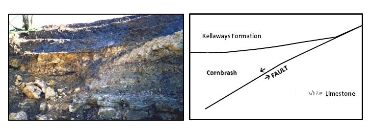
Here the JCB is working back into the corner of the quarry with the fault line. A very distinct red horizon has become visible between the grey clay at the top of the section and the underlying limestone. This has not been visible before. When the quarry work has finished a new log will be prepared by the group.

View to the gate by January 4th 2008 - the vegetation stripped leaving the hawthorn in place, dangerous drops re-landscaped into safe slopes

The White Limestone could now be seen for the first time in many months. Freshly exposed it is now ready for members of the group to go in and record the new sections, which now go deeper than they had ever been at this location.

Coombs current interpretation board.
Further reading suggestions:
Davies, L. (1994) Buckinghamshire rediscovered, Earth Heritage Magazine. EH2. pg.16-17 pdf
Ellis, N.V et al. (1996) An Introduction to the Geological Conservation Review. Chapter 6. pg.85-86 featuring quarry photo.
Eyers, J. (2002) Geological Walks in north Buckinghamshire. Thornborough Bridge and Coombs Quarry pg.18-21
Sumbler, M.G. (2002) Geology of the Buckingham district. Middle and Upper Jurassic pg.8-12
Images used with permission: © Copyright Buckinghamshire County Museum (Licence No. 44)
| BGG Contact : Mike Palmer (mpalmer@discoverbucksmuseum.org) page last updated: 9th April 2024 |
|
