|
Bucks Geology Group
Buckinghamshire's Hidden Geology
The rocks exposed at the surface in Buckinghamshire range from the Quaternary glacial deposits (less than 2.6 million years old) to the Upper Lias (Jurassic 190 million years old) in the north of the county. However, this is only part of the story, below the surface much older rocks are present.
The figure below shows a cross section through Buckinghamshire from north to south. The different rock layers are shaded by different colours. In order to display such a long distance, the section has been squeezed and the vertical scale exaggerated. This exaggeration helps to demonstrate the gentle dips of the surface rock layers, which dip to the South-East by 0.3 to 0.5 degrees.
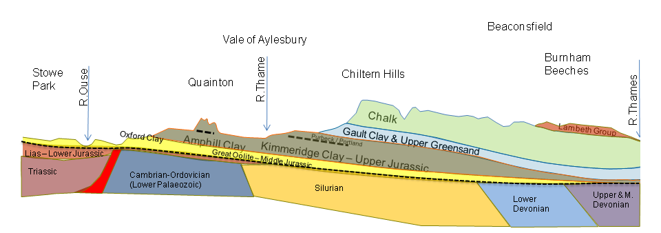
North to South geological cross section through Buckinghamshire (North on left. Exaggerated vertical scale)
The rocks below the surface have been discovered through various drilling endeavours, ranging from drilling water wells, to exploring for coal and oil. Geophysical surveys such as gravity and magnetics have been used to map the subsurface together with a small amount of seismic, which has been shot in north Bucks.
The most striking feature of the hidden geology of Buckinghamshire is the major unconformity that separates the lower Mesozoic rocks from the older Palaeozoic rocks. This unconformity represents the tilted remains of the London Platform, a long lived high block. The Mesozic rocks can be seen thinning and onlapping, in a SE direction, onto this surface until it was submerged during the Cretaceous. Below the unconformity a general trend can be determined from the borehole data, with the oldest Palaeozoic rocks (Cambrian-Ordovician) in the north of the County (Charlton Axis near Twyford shown in Blue) and the younger Palaeozoic (Silurian-Devonian) in the south of the County.
The Palaeozic rocks are themselves underlain by much older Pre-Cambrian rocks. It is expected that these rock will be very similar in nature to the Pre-Cambrian rocks exposed at Charnwood, Leicestershire, as they form part of the same microplate called the Midland Microcraton. The total thickness of the crust below Buckinghamshire is estimated to be around 10km thick. So there is far more hidden geology and rocks than that which can be discovered from the rocks exposed at the surface!
|
